GEOTECHNICAL ENGINEERING
CELBRIDGE
HomeInvestigationSPT (Standard Penetration Test)

SPT Testing in Celbridge – Reliable Ground Investigation for Local Developments

Practical geotechnics, field-tested.

LEARN MORE

Celbridge sits squarely on the limestone lowlands of County Kildare, where the River Liffey carves through a landscape left behind by retreating glaciers. That glacial history matters a lot when you are planning foundations: the drift geology here alternates between stiff, gravelly boulder clay and softer pockets of alluvial silt and sand, especially as you move closer to the floodplain. In our experience, the difference in N‑values within the same site can be striking — one borehole hits competent till at 2 metres, the next finds loose material down to 5 or 6. A proper SPT (Standard Penetration Test) run to ASTM D1586‑18 gives you that layering in black and white, with blow counts that translate directly into bearing capacity estimates. For projects near the historic Castletown demesne or along the Dublin Road, combining SPT data with a trial pit investigation often saves time, because you can visually confirm the transition from made ground into natural drift in the same campaign.

In Celbridge's glacial till, SPT refusal at shallow depth is a sign of strength, not a failed test — reading it correctly keeps foundations safe and saves unnecessary over-design.
Our service areas

How we work

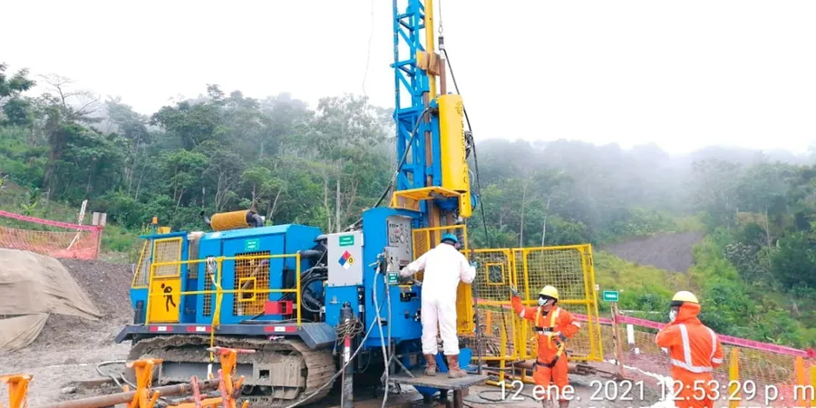
The kit we mobilise for Celbridge work is a standard safety hammer system on a tracked rig, which keeps ground pressure low when we are working on soft shoulders or back gardens in estates like St. Wolstan's or Primrose Gate. Each SPT run follows the usual 150 mm seating drive followed by three 150 mm increments, counting the blows for the last 300 mm of penetration — the N‑value that structural engineers in Kildare rely on. What catches people out around here is the cobble content in the lower till: refusal happens sooner than expected, and interpreting that correctly separates a useful investigation from a wasted borehole. We log the full depth profile, note where gravel-sized particles start jamming the split spoon, and when needed we switch to a solid cone tip to push through. In the laboratory, disturbed samples from the split spoon go straight to grain size distribution analysis so you know whether that silty sand layer is uniform or gap‑graded — a detail that changes drainage assumptions under your footing.
SPT Testing in Celbridge – Reliable Ground Investigation for Local Developments
Technical reference — Celbridge

Site-specific factors

The contrast between the north and south sides of the Liffey in Celbridge is something we see in almost every investigation. North of the river, around the Hazelhatch Road area, the ground is dominated by limestone‑rich till — generally dense, with N‑values climbing past 30 after three or four metres. South of the bridge, towards the Ardclough side, the profile changes: you pick up more water‑borne sand and soft silty layers that can give N‑values below 8 well into the depth of interest. That means a standard two‑storey extension in the south might need deeper strip footings or even a raft, while a similar structure north of the river sits comfortably on a metre‑wide trench fill. Skipping the SPT in the softer zones leads to differential settlement that shows up in cracked masonry within two or three winters. The water table around Celbridge also fluctuates with Liffey levels, so we always note the stabilised depth in the borehole log — it feeds directly into your shoring and drainage design.

Need a geotechnical assessment?

Reply within 24h.

Email: contact@geotechnical-engineering.co

Regulatory framework

ASTM D1586‑18 (Standard Test Method for Standard Penetration Test), IS EN ISO 22476‑3:2005 (Geotechnical investigation — Dynamic probing and SPT), Eurocode 7 (EN 1997‑1:2004): Geotechnical Design

Reference parameters

ParameterTypical value
Standard followedASTM D1586‑18 / IS EN ISO 22476‑3:2005
Hammer typeSafety hammer with rope and cathead
SamplerStandard 2" OD split spoon (solid cone tip for gravel refusal)
Seating drive150 mm (6") before counting
Test increment150 mm (6") per drive, total 450 mm
Energy correctionNormalised to N₆₀ (60% theoretical free-fall energy)
Typical depth range in Celbridge1.5 m – 10 m (depending on refusal in till)

Frequently asked questions

How much does an SPT investigation in Celbridge typically cost?

For a residential or light commercial project in Celbridge with two to three boreholes to depths of 4–6 metres, the cost generally falls between €540 and €590 per borehole. The final figure depends on access conditions, the depth to refusal in the till, and whether you need a combined laboratory testing package on the recovered samples.

How many boreholes do I need for a house extension in Celbridge?

For a typical single‑storey extension, two boreholes positioned diagonally across the footprint usually give enough information to spot any lateral variation in the glacial drift. If the site is within 200 metres of the River Liffey or shows signs of past filling, we often recommend a third borehole to pin down the extent of soft alluvial layers.

What does the SPT refusal mean in Celbridge's glacial till?

Refusal happens when 50 blows advance the split spoon less than 150 mm. In Celbridge, refusal often occurs between 2.5 and 5 metres when the sampler hits dense, cobble‑rich lodgement till. That refusal is not a failed test — it indicates a very competent bearing stratum, and our report will treat that depth as the point where end‑bearing resistance increases sharply.

Can the SPT tell me if my site has a liquefaction risk?

Celbridge is in a low‑seismicity region, so conventional liquefaction assessment is rarely triggered by building control. However, in loose saturated silty sands found in the Liffey floodplain, the SPT N‑values combined with groundwater readings can be used with Seed‑Idriss simplified procedure to evaluate cyclic stress ratio if the project is a high‑importance structure.

Location and service area

We serve projects across Celbridge and surrounding areas.

View larger map