GEOTECHNICAL ENGINEERING
CELBRIDGE
HomeInvestigationCPT (Cone Penetration Test)

Cone Penetration Testing (CPT) in Celbridge

Practical geotechnics, field-tested.

LEARN MORE

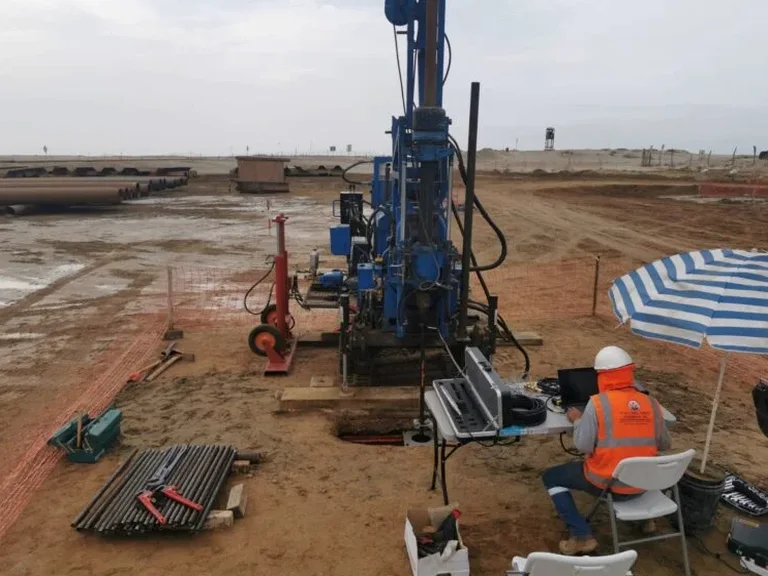
In Celbridge we keep seeing the same pattern. A site looks fine on the surface but the ground underneath tells a different story. Much of the town sits on glacial till overlying Carboniferous limestone. The till is dense. It's stony. It varies over short distances. Standard drilling struggles here. The CPT pushes a cone through these deposits and records resistance continuously. You get a sharp profile of where the till tightens up and where the limestone bedrock begins. For engineers working along the R403 or near Castletown House, this data is gold. We run the test with a 20-tonne rig and a 15 cm² cone. The friction sleeve picks up subtle changes in clay content. The pore pressure transducer flags silt lenses before they become a problem during excavation. When the Liffey is high after winter rain, we often combine this with an in-situ permeability assessment to check how groundwater moves through the upper drift.

In Celbridge's mixed glacial deposits, a single CPT sounding often reveals more about stratigraphy than three boreholes combined.
Our service areas

How we work

The test follows IS EN ISO 22476-1:2013. That's the European standard for electrical cone and piezocone testing. In Celbridge the standard matters because of the limestone. The cone hits rock at varying depths. Sometimes at 4 m. Sometimes at 12 m. A mechanical hammer drill would lose information in the transition zone. The CPT captures that transition as a sharp rise in tip resistance. We log at 20 mm intervals. That's 50 readings per metre. No other field test gives you that resolution in real time. We measure three things simultaneously. Tip resistance qc. Sleeve friction fs. And dynamic pore pressure u2. From those we derive the friction ratio Rf and the soil behaviour type. The system classifies the ground every centimetre. In the floodplain near the Liffey we often see soft alluvium over dense till. The CPT splits those two layers with precision. This is where a grain-size analysis on a disturbed sample would miss the in-situ density. The cone captures it directly.
Cone Penetration Testing (CPT) in Celbridge
Technical reference — Celbridge

Site-specific factors

Celbridge sits at roughly 55 m above sea level, but the Liffey valley drops to the north. Flooding is a real concern. The CFRAM maps show significant flood risk along the river corridor. When water saturates the alluvial layer, the soil loses strength fast. A CPT run after a wet winter tells you exactly how much the undrained shear strength has dropped. We've seen su values halve in the upper 3 m compared to summer readings. That matters for shallow footings. It matters for retaining walls. Another issue is the limestone bedrock. It's karstic in places. The cone can detect voids indirectly through sudden drops in tip resistance. Not every void shows up. But a sudden drop to near zero at 8 m in Celbridge is a red flag. It warrants follow-up with resistivity profiling to map possible dissolution features before committing to a foundation design. Skipping the CPT in this geology means guessing. Guessing in karst limestone is expensive.

Need a geotechnical assessment?

Reply within 24h.

Email: contact@geotechnical-engineering.co

Regulatory framework

IS EN ISO 22476-1:2013 – Geotechnical investigation and testing. Field testing. Electrical cone and piezocone penetration test., IS EN 1997-2:2007 (Eurocode 7 Part 2) – Ground investigation and testing., NRA HD 22/08 (now TII) – Ground investigation for road schemes in Ireland, referencing CPT for pavement and embankment design.

Reference parameters

ParameterTypical value
StandardIS EN ISO 22476-1:2013 (electrical CPT/CPTU)
Cone type15 cm² electrical cone, 60° apex angle
Penetration rate20 mm/s ± 5 mm/s, constant
Measured parametersqc, fs, u2 (piezocone)
Logging interval20 mm (Class 1)
Maximum depth30 m (bedrock refusal in Celbridge typically 4-15 m)
Friction sleeve area150 cm²
Pore pressure filterSaturated, glycerol-deaired, u2 position

Frequently asked questions

How deep can a CPT go in Celbridge?

It depends entirely on the ground. In the softer alluvium near the Liffey we can push to 25 m or more without trouble. On the higher ground where the glacial till is dense and stony, refusal typically occurs between 8 and 15 m. The rig pushes with 20 tonnes of force. When tip resistance exceeds 50 MPa over a sustained interval, we stop. That's usually the limestone bedrock surface.

Do I need both CPT and boreholes for a house extension?

For a single-storey extension on a straightforward site, a CPT alone can be enough. It gives you bearing capacity and a soil profile. But if the cone hits refusal at 1.5 m and you suspect a boulder rather than bedrock, a single borehole or a test pit clarifies the obstruction. We discuss this case by case.

What does a CPT test cost in the Celbridge area?

Mobilisation and testing typically ranges from €130 to €220 per sounding, depending on depth achieved and whether piezocone or seismic modules are needed. A full day on site with multiple soundings brings the per-test cost down. We quote a fixed price after reviewing the site location and access.

Can CPT detect cavities in the limestone?

Not directly. The cone measures soil and rock resistance. A large air-filled void would show as a sudden drop in qc to near zero, followed by a spike when the cone hits the far wall. But small voids or narrow fissures can be missed. If karst features are suspected, we recommend combining CPT with resistivity or seismic tomography for better coverage.

How long does a CPT test take on site?

A single 15 m sounding takes about 45 minutes of actual pushing. Setup and breakdown add another 30 minutes. For a typical Celbridge site with three soundings, we are usually on and off site within half a day. Data is processed in real time. You see the soil profile on screen as the cone advances.

Location and service area

We serve projects across Celbridge and surrounding areas.

View larger map